According to the National Weather Forecasting Centre of the India Meteorological Department (IMD):
Salient features of month of Feb 2021
(a) Western Disturbances (WDs):
Six WDs and four induced cyclonic circulations affected Northwest India during Feb 2021. Among these, two WDs caused scattered to fairly widespread rainfall/snowfall activity over Western Himalayan Region and isolated to scattered rainfall/thunderstorm activity over adjoining plains of Northwest India. Isolated hailstorm activity also occurred over Western Himalayan Region during the passage of these two systems.
(b) Wet spell over central, peninsular and adjoining eastern India:
A Wet spell with isolated Hail storm occurred over Central, eastern India, Maharashtra during 16-19 Feb and then over Peninsular India during 19-22 Feb 2021, under the influence of interaction of mid-latitude westerly winds in middle and upper troposphere and lower level easterly winds.
(c) Monthly Rainfall Scenario over the country (01 to 28 Feb2021):
Rainfall over the country as a whole for the month of Feb,2021 was 7.6 mm, which was -68% less than its Long Period Average (LPA) of 23.5 mm as shown in Table 1. Fig. 1 shows Meteorological subdivision-wise rainfall during Jan 2021. During this month, 9 sub-divisions received large excess, 2 normal while remaining 23 received deficient or large deficient rainfall and 2 (Saurashtra & Kutch and west Rajasthan) received no rain.
(d) Occurrence of Unusual prolonged spells of very dense fog over Punjab and Haryana during 10-22 Feb 2021:
As per surface observations and satellite images from INSAT 3D, extensive dense to very dense fog were reported persistently from late night till late morning almost every day during the period of 10-22 Feb 2021 over many areas of Punjab and Haryana. Fig 2 shows this dense fog coverage as captured by INSAT 3D at 0845 hours IST of each date for the period of 11-21 Feb. 2021. Due to such dense fog, visibility was reduced to < 200m during night to morning in most dates over these areas. In Amritsar, for 1-28 Feb. 2021, dense fog in the month in total was observed for 15 days with 168 hours. This dense fog frequently extended eastwards over parts of Delhi and west Uttar Pradesh and also southwards, to northwestern parts of Rajasthan (refer Fig 2) for around 7-10 days during the period. It was observed for 7 days with a total of 28 hours at IGI Airport, Delhi.
3. Weather Outlook for March 2021
3.1 Temperature outlook for March 2021

Fig3a. Probability forecast &Subdivision averaged Maximum Temperature Anomaly for March 2021

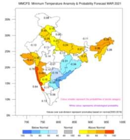
Fig3b. Probability forecast &Subdivision averaged Minimum Temperature Anomaly for March 2021

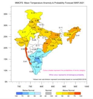
Fig3c. Probability forecast &Subdivision averaged Mean Temperature Anomaly for March 2021
Fig.3a, Fig.3b and Fig.3c show the probability forecast and anomaly (departures from the long term normal) forecasts for the subdivision averaged maximum, minimum and mean temperatures respectively for the month of March 2021.
The probability forecast for maximum temperature (Fig.3a) indicates that above normal maximum temperature are likely over most subdivisions of north Indian plains adjacent to Himalayas, west, east and northeast India and a few subdivisions of central India.
The probability forecast for minimum temperature (Fig.3b) indicates that above normal minimum temperatures are likely to be over most subdivisions of north India along the foot hills of Himalayas, north east India and few subdivisions of west and western coastal India. Subdivisions of Odisha, Chhattisgarh, Telangana, Rayalaseema and Coastal Andhra Pradesh are likely to experience below normal minimum temperatures.
The probability forecast for mean temperature (Fig.3c) indicates above normal mean temperature over most subdivisions of north India along the foothills of Himalayas, northwest, west, northeast and east India and a few subdivisions of western coast.
Forecast:Rainfall Forecast
Weeks 1 (5 – 11 March, 2021)
· Under the influence of current Western Disturbance (WD), light isolated rainfall/snowfall very likely over WHR on 4th & 5th March, 2021.Thereafter, a fresh WD is very likely to affect WHR & adjoining plains from 6th March and cause fairly widespread to widespread rainfall/snowfall over the region during 06th – 08th March with peak intensity on 07th March. Isolated heavy rainfall/snowfall alongwith lightning & hailstorm very likely over Jammu, Kashmir, Ladakh, Gilgit, Baltistan & Muzaffarabad, Himachal Pradesh and Uttarakhand on 07th March. Isolated to scattered light rain/drizzle very likely over Punjab on 06th & 07th and isolated light rain/drizzle over north Haryana, Chandigarh and adjoining West Uttar Pradesh on 07th March.
Thereafter, two fresh WDs in quick succession are very likely to affect WHR from 9th to 15th March and cause scattered to fairy widespread rainfall/snowfall over the region. (refer Fig 4 and 5).
Scattered to fairly widespread rainfall with isolated thunderstorm/lightning very likely over northeastern states during the week 1.
Overall rainfall activity is very likely to above normal over WHR and northeastern states during Week 1.
Isolated to scattered light rainfall with isolated thunderstorm/lightning very likely over East Uttar Pradesh, Bihar, East Madhya Pradesh, Chhattisgarh, Jharkhand &Odisha during 11-13th March 2021.
Weeks 2 (12 – 18 March, 2021)
· In Week 2, it is very likely to be above normal rainfall over Jammu & Kashmir and normal to above normal over rest WHR and northeastern states. It is likely to below normal to normal over remaining parts of the country. (refer Fig 4 and 5).
Week 3: (19 to 25 March)
· In Week 3, it is very likely to be below normal rainfall over most parts of India including Jammu & Kashmir and adjoining parts of northern India due to absence of major WD likely to affect the country while normal to above normal over parts of southeastern Peninsular India and northeastern states. (refer Fig 4 and 5).
Week 4:26-31 March, 2021
· In Week 4, it is very likely to be above normal rainfall over Jammu & Kashmir and parts of Punjab, Haryana, parts of Rajasthan, parts of northeastern states, Sothern parts of Maharashtra and southern parts of peninsular India. It is likely to be below normal to normal over remaining parts of the country. (refer Fig 4 and 5).
3.3. Cyclogenesis:
• No cyclogenesis is likely over the north Indian Ocean during next two weeks.
Please CLICK HEREfor details and graphics.
Kindly download MAUSAM APP for location specific forecast & warning, MEGHDOOT APP for Agromet advisory and DAMINI APP for Lightning Warning.
***
NB/KGS/(IMD Release)

