According to the National Weather Forecasting Centre/Regional Meteorological Centre, New Delhi of the India Meteorological Department (IMD):
Significant Weather Features
|
♦ The Monsoon Trough lies to the north of its normal position. Western end of the Monsoon Trough is likely to remain close to foothills of Himalayas during next 5 days and the eastern end is likely to shift southwards from 19th September onwards. ♦ An east-west shear zone runs roughly along Latitude 15°N between 3.6 & 5.8 km above mean sea level. It is likely to persist during next 2 days and weaken thereafter. ♦ Due to the above favourable meteorological conditions, Fairly widespread to widespread rainfall with isolated heavy falls very likely over Coastal Andhra Pradesh, Telangana, Madhya Maharashtra, Marathwada, Coastal & North Interior Karnataka and Kerala &Mahe during next 3days. ♦ Under the influence of likely formation of a Low Pressure Area over Northeast Bay of Bengal and consequent strengthening of lower level winds along the West Coast; Fairly widespread to widespread rainfall with Isolated heavy to very heavy falls are likely over Andaman & Nicobar Islands, Odisha, Coastal & South Interior Karnataka and Kerala during 19th-20th September,2020. ♦Moderate thunderstorm with lightning very likely at isolated places over Madhya Pradesh, Vidarbha, Bihar, Jharkhand, Assam & Meghalaya, Madhya Maharashtra, Marathwada, Coastal Andhra Pradesh &Yanam, Odisha, Telangana, Kutch region, Southeast & Northwest Uttar Pradesh, South Rajasthan and Chhattisgarh during next 12 hours. |
Weather Warning during next 5 days *
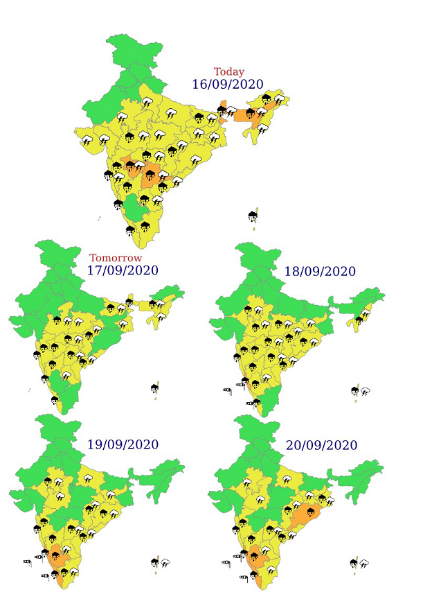
16 September (Day 1):♦ Heavy to very heavy rainfall with extremely heavy falls very likely at isolated places over Assam & Meghalaya; heavy to very heavy rainfall at isolated places over Sub-Himalayan West Bengal & Sikkim, Marathwada, Telangana and heavy rainfall at isolated places over West Madhya Pradesh, Vidarbha, Bihar, Andaman & Nicobar Islands, Arunachal Pradesh, Madhya Maharashtra, Konkan & Goa, Coastal Andhra Pradesh &Yanam, Rayalaseema, Coastal & North Interior Karnataka, Kerala &Mahe and Tamilnadu, Puducherry &Karaikal.
♦ Thunderstorm accompanied with lightning at isolated places over Madhya Pradesh, Vidarbha, Bihar, West Bengal & Sikkim, Arunachal Pradesh, Assam & Meghalaya, Nagaland, Manipur, Mizoram & Tripura, Madhya Maharashtra, Marathwada, Kutch & South Gujarat Region, North Jharkhand, South Interior Odisha, Northwest & Southeast Uttar Pradesh, Southeast Rajasthan, Chhattisgarh, Coastal Andhra Pradesh &Yanam, Telangana and Rayalaseema.
♦ Strong Wind (speed reaching 45-55 kmph) very likely over Southwest Arabian Sea. Fishermen are advised not to venture into these areas.
17 September (Day 2):♦ Heavy rainfall at isolated places over West Madhya Pradesh, Vidarbha, Bihar, Sub-Himalayan West Bengal & Sikkim, Andaman & Nicobar Islands, Assam & Meghalaya, Madhya Maharashtra, Marathwada, Konkan & Goa, Coastal Andhra Pradesh &Yanam, Telangana, Coastal & North Interior Karnataka and Kerala &Mahe.
♦ Thunderstorm accompanied with lightning at isolated places over Madhya Pradesh, Vidarbha, Chhattisgarh, Bihar, Gangetic West Bengal, Assam & Meghalaya, Nagaland, Manipur, Mizoram & Tripura, Coastal Andhra Pradesh &Yanam, Telangana and Rayalaseema.
♦ Strong Wind (speed reaching 45-55 kmph) very likely over Southwest Arabian Sea. Fishermen are advised not to venture into these areas.
18 September (Day 3):♦ Heavy to very heavy rainfall likely at isolated places over Coastal Karnataka and heavy rainfall at isolated places over southeast Rajasthan, Madhya Pradesh, Vidarbha, Odisha, Andaman & Nicobar Islands, Nagaland, Madhya Maharashtra, Marathwada, Konkan & Goa, Coastal Andhra Pradesh &Yanam, Telangana, Interior Karnataka and Kerala &Mahe.
♦Thundersquall (speed 50-60 kmph) accompanied with lightning very likely at isolated places over Andaman & Nicobar Islands; moderate thunderstorm accompanied with lightning likely at isolated places over southeast Rajasthan and thunderstorm accompanied with lightning at isolated places over Madhya Pradesh, Vidarbha, Chhattisgarh, Jharkhand, Odisha, Nagaland, Manipur, Mizoram & Tripura, Coastal Andhra Pradesh &Yanam, Telangana andRayalaseema.
♦ Strong Wind (speed reaching 45-55 kmph) likely over Southwest Arabian Sea and along & off Kerala-Karnataka coasts and Lakshadweep area; Gulf of Mannar and Southwest Bay of Bengal, Southeast & adjoining Eastcentral Bay of Bengal and Andaman Sea.Fishermen are advised not to venture into these areas.
19 September (Day 4):♦ Heavy to very heavy rainfall likely at isolated places over Andaman & Nicobar Islands, Coastal & South Interior Karnataka and Kerala &Mahe and heavy rainfall at isolated places over southeast Rajasthan, Odisha, Madhya Maharashtra, Konkan & Goa, Coastal Andhra Pradesh &Yanam, Telangana, North Interior Karnataka and Tamilnadu, Puducherry &Karaikal.
♦ Thundersquall (speed 50-60 kmph) accompanied with lightning very likely at isolated places over Andaman & Nicobar Islands; moderate thunderstorm accompanied with lightning likely at isolated places over East Uttar Pradesh and southeast Rajasthan and thunderstorm accompanied with lightning at isolated places over West Madhya Pradesh, Chhattisgarh, Jharkhand, Odisha, Coastal Andhra Pradesh &Yanam, Telangana, Rayalaseema and Tamilnadu, Puducherry &Karaikal.
♦ Strong Wind (speed reaching 45-55 kmph) likely over Southwest Arabian Sea and along & off Kerala-Karnataka coasts and Lakshadweep area; Gulf of Mannar and Southwest Bay of Bengal, Southeast &Eastcentral Bay of Bengal and Andaman Sea.Fishermen are advised not to venture into theseareas.
20 September (Day 5):♦ Heavy to very heavy rainfall likely at isolated places over Odisha, Coastal & South Interior Karnataka and Kerala &Mahe and heavy rainfall at isolated places over south Chhattisgarh, Gangetic West Bengal, Andaman & Nicobar Islands, Madhya Maharashtra, Konkan & Goa, Coastal Andhra Pradesh &Yanam, Telangana and North Interior Karnataka.
♦Thundersquall (speed 50-60 kmph) accompanied with lightning very likely at isolated places over Andaman & Nicobar Islands; moderate thunderstorm accompanied with lightning likely at isolated places over East Uttar Pradesh and southeast Rajasthan and thunderstorm accompanied with lightning at isolated places over West Madhya Pradesh, Chhattisgarh, Jharkhand, Gangetic West Bengal, Coastal Andhra Pradesh &Yanam, Telangana, Rayalaseema and Tamilnadu, Puducherry &Karaikal.
♦ Strong Wind (speed reaching 45-55 kmph) likely over Southwest Arabian Sea and along & off Kerala-Karnataka coasts and Lakshadweep area; Gulf of Mannar and Southwest Bay of Bengal, Northeast, Southeast &Eastcentral Bay of Bengal and Andaman Sea.Fishermen are advised not to venture into these areas

|
Kindly download MAUSAM APP for location specific forecast &warning, MEGHDOOT APP for Agrometadvisory and DAMINI APP for Lightning Warning &visit state MC/RMC websir district wise warning. |

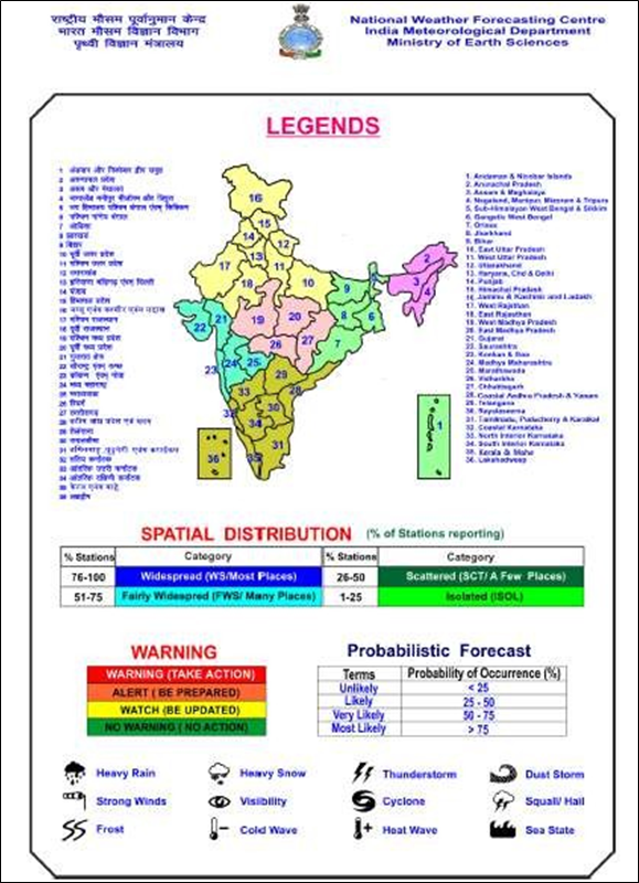
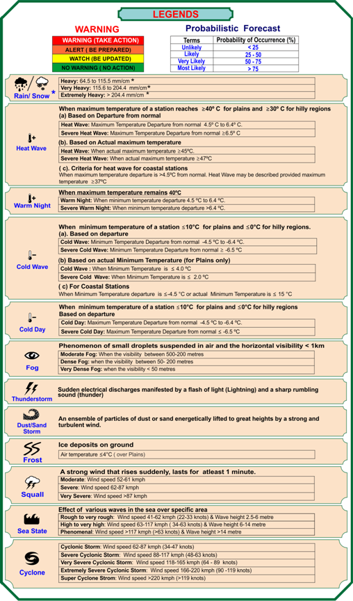
Legends: Heavy rain: 64.5-115.5 mm/day;
Very heavy rain: 115.6-204.4 mm/day;
Extremely heavy rain: Greater or equal to 204.5 mm/day
For further details and forecast updates kindly visit websites of IMD, New Delhi:http://www.mausam.imd.gov.in

***
NB/KGS/(IMD Release)

