PolarGAP has been successful in surveying the last major unknown region on Earth at the South Pole. This was done by European scientists that have flown several instruments back and forth across the pole to map its hidden depths.
Known as PolarGAP, the project was largely funded by the European Space Agency (Esa) to gather measurements over an area of Earth that its satellites cannot see, as they generally only fly up to about 83 degrees in latitude.
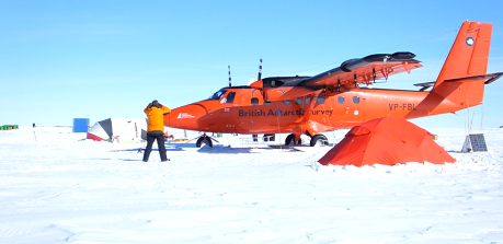
To get the information, the PolarGAP team flew an instrumented Twin Otter plane across the polar landscape in grid lines that totalled some 30,000km. As well as gravity and magnetic sensors, the airborne campaign carried a radar and a laser altimeter.
The radar provides insights on the layers and total thickness of the ice sheet. It also maps the shape of the rockbed and gives some information on the movement of water at the ice-rock interface.
Gravity data helps determine the thickness of the crust – the platform on which Antarctica stands. Magnetics is complementary and says something about the presence of magmatic rocks and sedimentary basins. The laser captures the shape of the top ice surface.
Much of this data is still being processed, but already the team can confirm the existence of a vast basin that appears to play a key role in controlling the flow of ice towards the ocean.
The PolarGAP data will make future global models much more accurate, and together with similar data collected over decades in the Arctic, including data from recent [UN treaty] activities and declassified gravity data from the Cold War, secure 100% global coverage.
Another use will be to assist geologists in their choice of location to drill to the rockbed. No-one has yet pulled up rock samples from under the middle of the Antarctic ice sheet.
About Project PolarGap:
The polar regions have the capacity to amaze and astound, but despite the considerable progress of recent decades we still know far less about them than less remote parts of the world.
PolarGAP is an ambitious international mission to capture new and critical data about the Earth’s global gravity field. Innovative radar systems and Lidar technologies will also be deployed from Twin Otter aircraft to fill the ‘data gap’ in measurements of surface elevation over the South Pole region south of 83.5°.
Two earth observing satellite missions (GOCE and CryoSat 2) mounted by the European Space Agency (ESA) revolutionised scientists’ ability to ‘map’ the Earth’s global gravity field and monitor how Earth’s ice fields are responding to global change. However, because GOCE’s orbit did not cross the Poles there is a data gap at the South Pole.
Primary aim of the Project:
Fill the Antarctic polar gap in GOCE satellite gravity coverage through collection of new airborne gravity data and combination with data from existing surveys in the South Pole region.
Validation of differences in surface elevation observed by CryoSat-2 when traveling in opposite directions, by using airborne Lidar and the the innovative ASIRAS Radar System to measure the ice sheet surface and structure of the shallow snow pack.
Additional aims:
Exploring the geological structure and evolution of East and West Antarctica in the South Pole region with new magnetic and gravity data.
Investigating Antarctic ice sheet dynamics around South Pole using airborne radar to map the sub-ice mountains and valleys, distribution of subglacial water and internal ice sheet structures.